Map Analysis
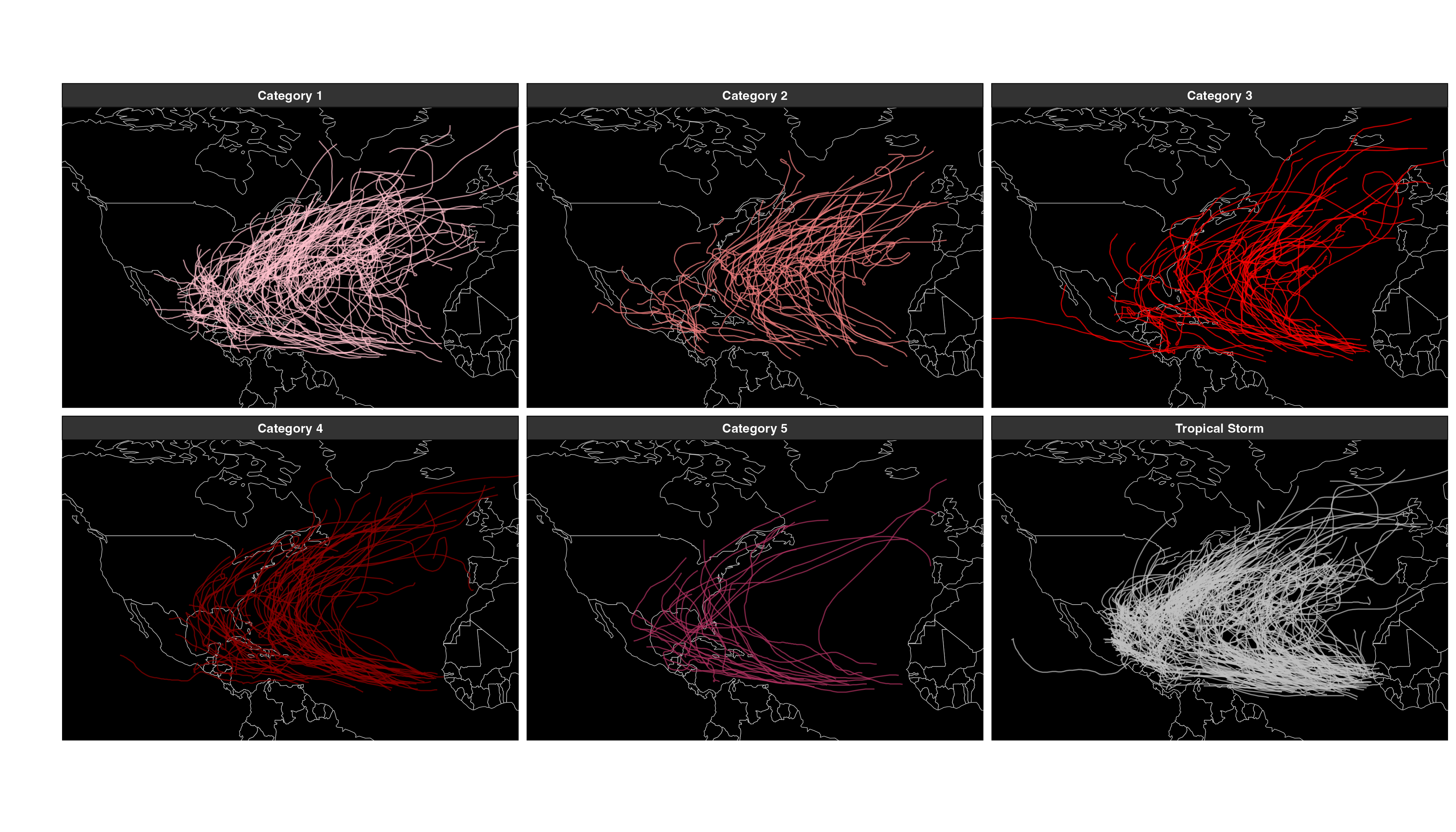
Tropical Cyclone Tracks in the North Atlantic by Category
- Categories 1–2 are quite spread out, extending well into mid-latitudes.
- Categories 3–4 still appear widely but show more clustering near warmer waters.
- Category 5 storms are rarer, typically tracking through the warmest tropical regions.
- Tropical storms are the most numerous, covering almost the entire North Atlantic basin.
Plot of hurricanes that made landfall in 2005
Show Code
# Filter for storms in 2005
dat_2005 <- dat |> filter(SEASON == 2005)

# Identify storms that made landfall
dat_2005_land <- dat |>
  filter(SEASON == 2005, LANDFALL == 0) |>
  select(SID)

# Keep only storms that made landfall
dat_2005 <- inner_join(dat_2005, dat_2005_land, by = "SID")

# Count unique hurricanes
n <- dat_2005 |> count(NAME) |> summarize(n = n()) |> pull(n)

# Generate a color palette using viridis
pal = colorFactor(
  palette = rainbow(n = n),
  domain = dat_2005$NAME
)

# Create interactive Leaflet map
leaflet(dat_2005) |>
  setView(lng = -50, lat = 30, zoom = 3) |>
  addTiles() |>
  addCircleMarkers(
    lng = ~LON,
    lat = ~LAT,
    radius = ~WMO_WIND / 20,  # Scaled marker size by wind speed
    color = ~pal(NAME),
    stroke = TRUE,
    weight = 1,
    fillOpacity = 0.7,
    popup = ~paste("<b>Hurricane:</b> ", NAME, "<br>",
                   "<b>Wind Speed:</b> ", WMO_WIND, " knots")  # Clickable popup
  ) |>
  addControl(
    "<strong>Hurricanes Making Landfall (2005)</strong>",
    position = "topright",
    className = "map-title"
  )
Visualizing starting points
The starting points along with the respective tracks are mapped for each Category of hurricane depending on the starting month. Interesting observations are commented below each group of maps.
Category 1
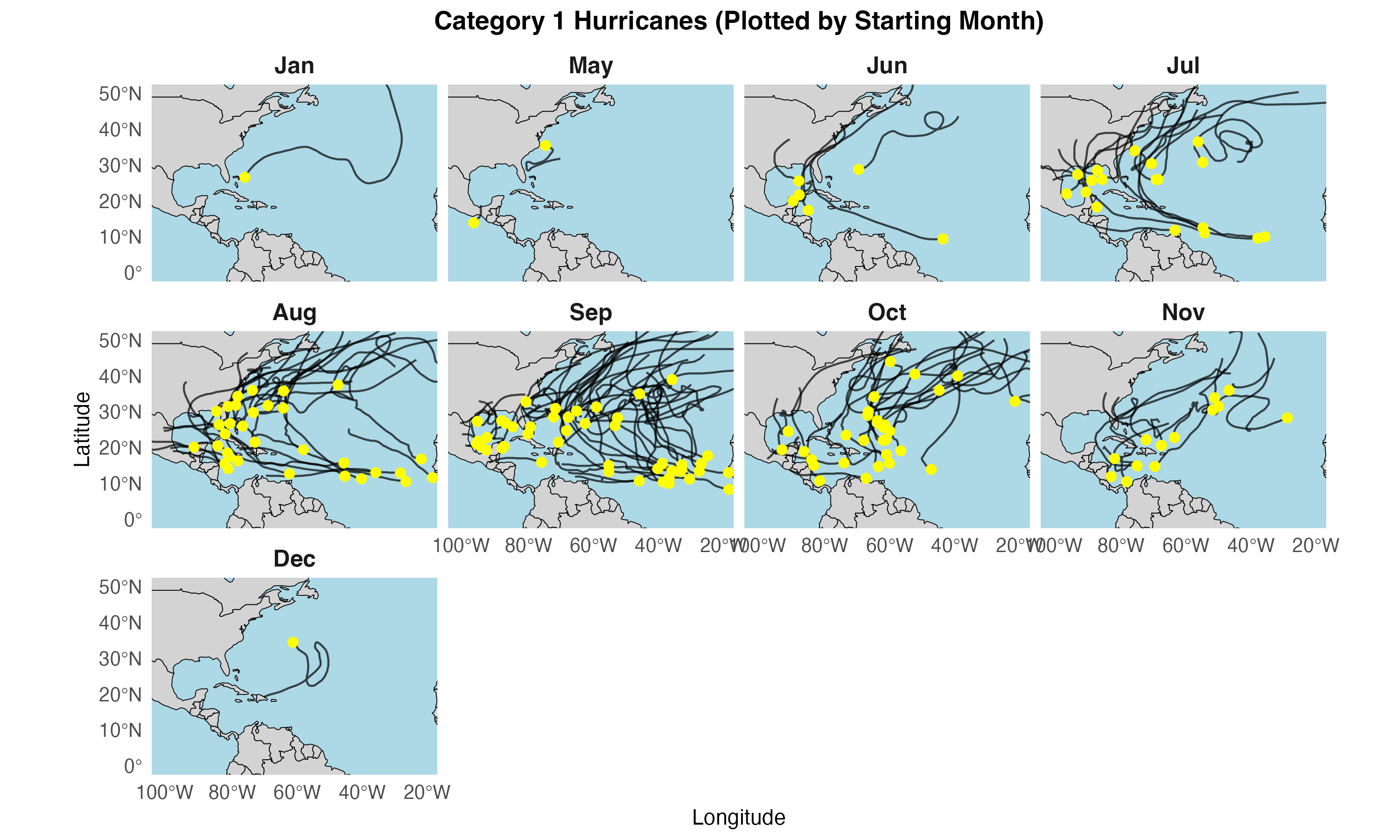
- Early months (Jan–May) see minimal formation.
- Peak activity (Aug–Oct) shows storms often originating near West Africa or in the Caribbean/Gulf.
- Late-season storms (Nov–Dec) become rarer and form closer to the tropics.
Category 2
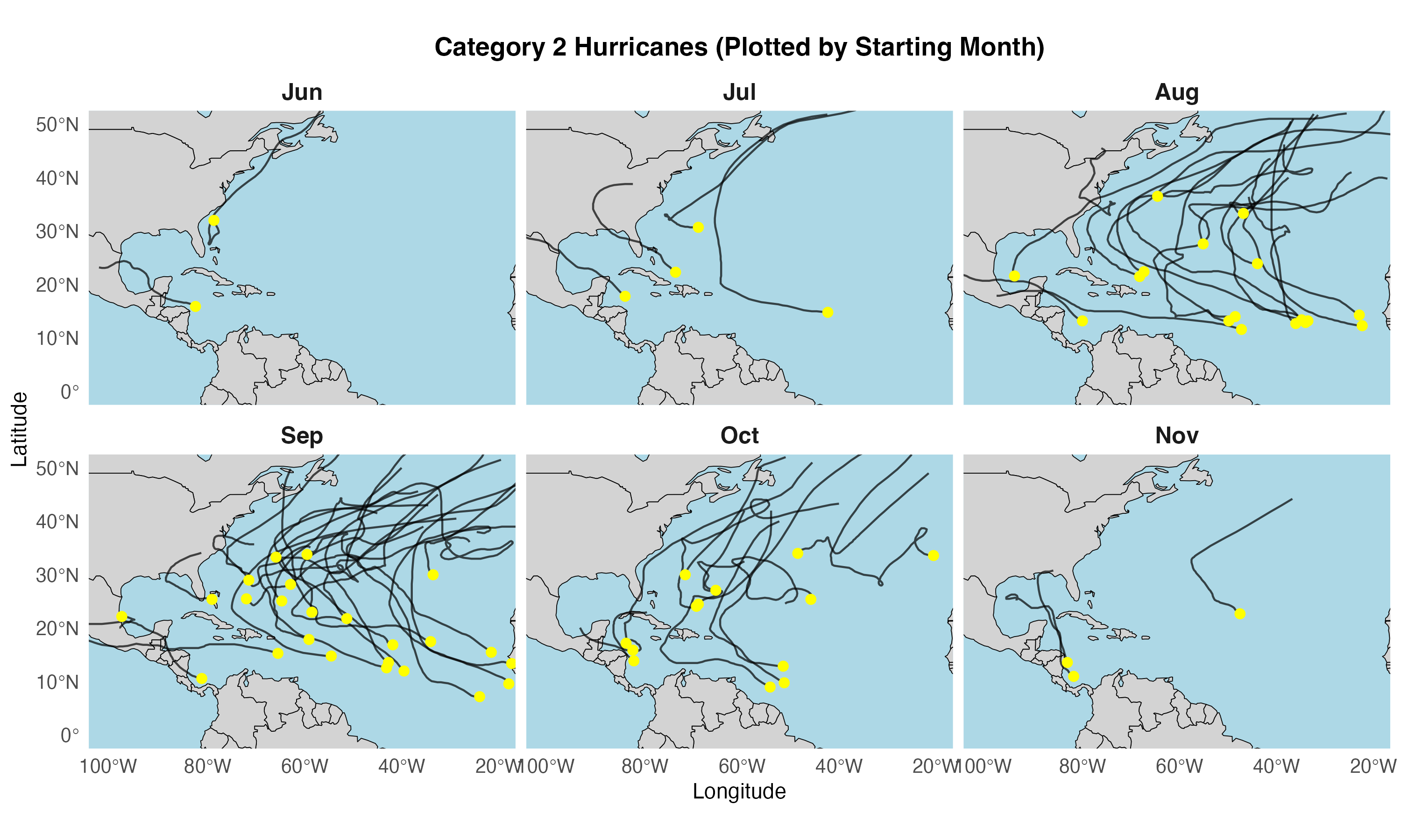
- June–July storms often form closer to the Caribbean and Gulf regions.
- August sees many storms originating off the West African coast, tracking westward.
- September–October remain the peak formation months, with wider dispersion across the Atlantic.
- November shows fewer storms, generally forming in warmer tropical waters closer to the Caribbean.
Category 3
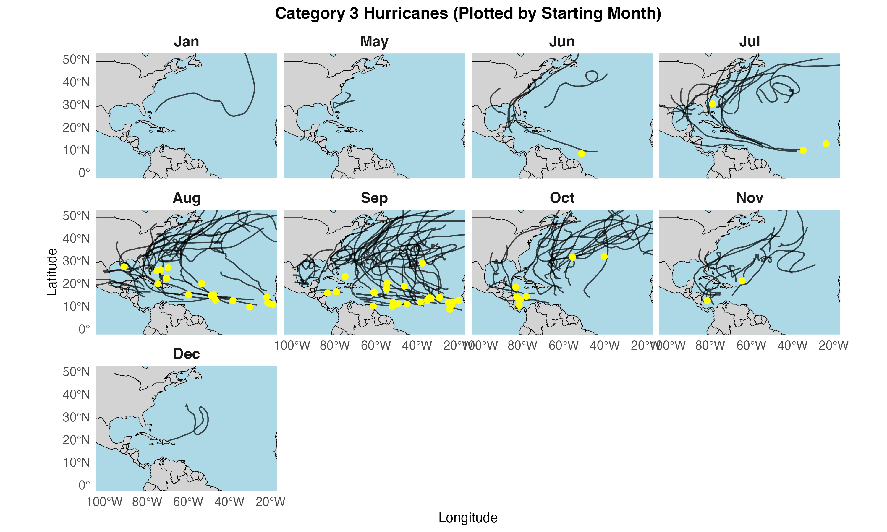
- January to May: Minimal cyclone activity is observed during these months, with only isolated events generally forming in persistently warm equatorial regions.
- June to July: The onset of the hurricane season is evident as storm genesis begins to increase, particularly within the Gulf of Mexico and the Caribbean Sea.
- August to September: This interval represents the peak period for hurricane development, with a majority of systems originating near the West African coast and across the primary tropical development region of the Atlantic basin.
- October: A transitional phase is noted, with cyclone formation shifting predominantly toward the Caribbean and Gulf regions, reflecting the gradual decline of seasonal activity.
- November to December: As the season nears its end, a marked reduction in storm formation is evident, with only a few localized events occurring.
Category 4
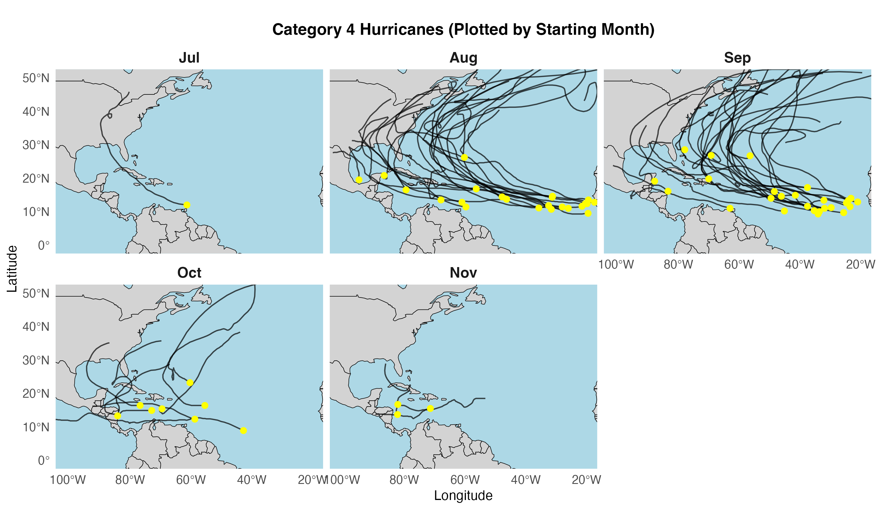
- July: Storm activity begins to rise, primarily originating in the Gulf of Mexico and the Caribbean region.
- August: Formation intensifies, often commencing off the West African coast and traversing the main development region of the Atlantic.
- September: The peak of hurricane season features widespread cyclone genesis across the tropical Atlantic, from West Africa to the Caribbean.
- October: Activity shifts predominantly westward, with a focus on the Gulf of Mexico and Caribbean as conditions cool in the mid-Atlantic.
- November: The season tapers off, with fewer storms typically forming in warmer, lower-latitude waters near Central America and the Caribbean.
Category 5
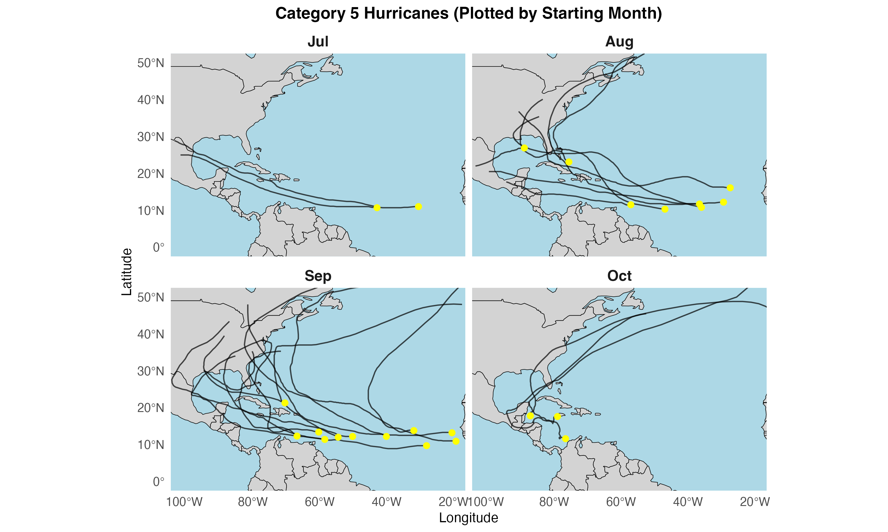
- July: Cyclogenesis intensifies, primarily in the Gulf of Mexico and the Caribbean Sea, marking the buildup to the season’s peak.
- August: Storms expand eastward into the central Atlantic, sustained by increasingly warm sea surfaces and favorable atmospheric conditions.
- September: The season’s peak activity often emerges off West Africa and propagates through the tropical Atlantic, contributing to the highest overall storm frequency.
- October: Activity tapers as storms concentrate in the western Caribbean and Gulf regions, reflecting the gradual seasonal shift.
Starting points of Hurricane 5’s that made landfall
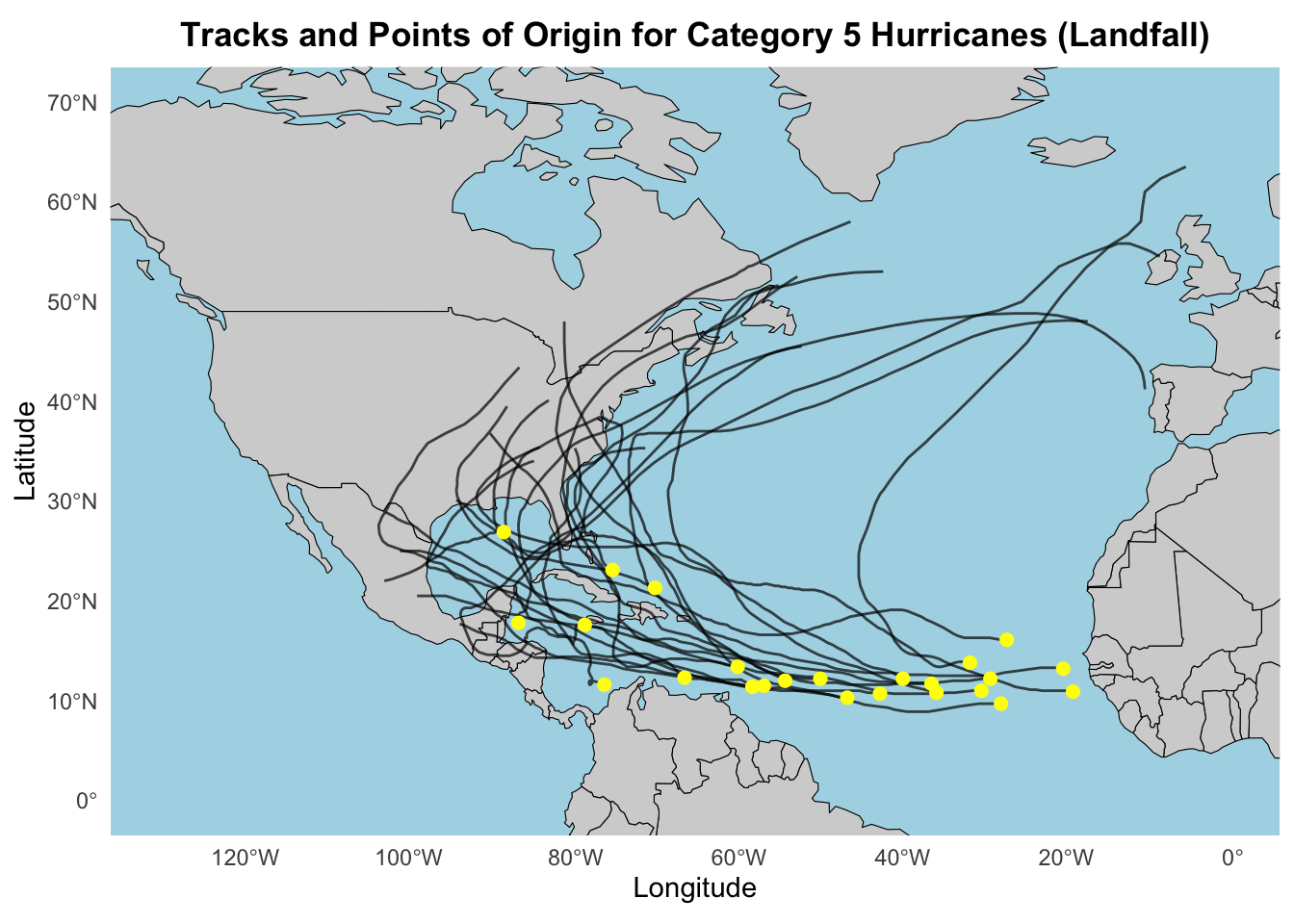
- Most Category 5 hurricanes initiating in the tropical Atlantic gradually intensify as they cross warm waters.
- Their paths typically span from the eastern Atlantic near West Africa to the Caribbean Sea, Gulf of Mexico, and the southern United States.
- These landfall events underscore the role of ocean heat content and conducive atmospheric conditions in fostering storms of extreme intensity.
Faceted by starting month
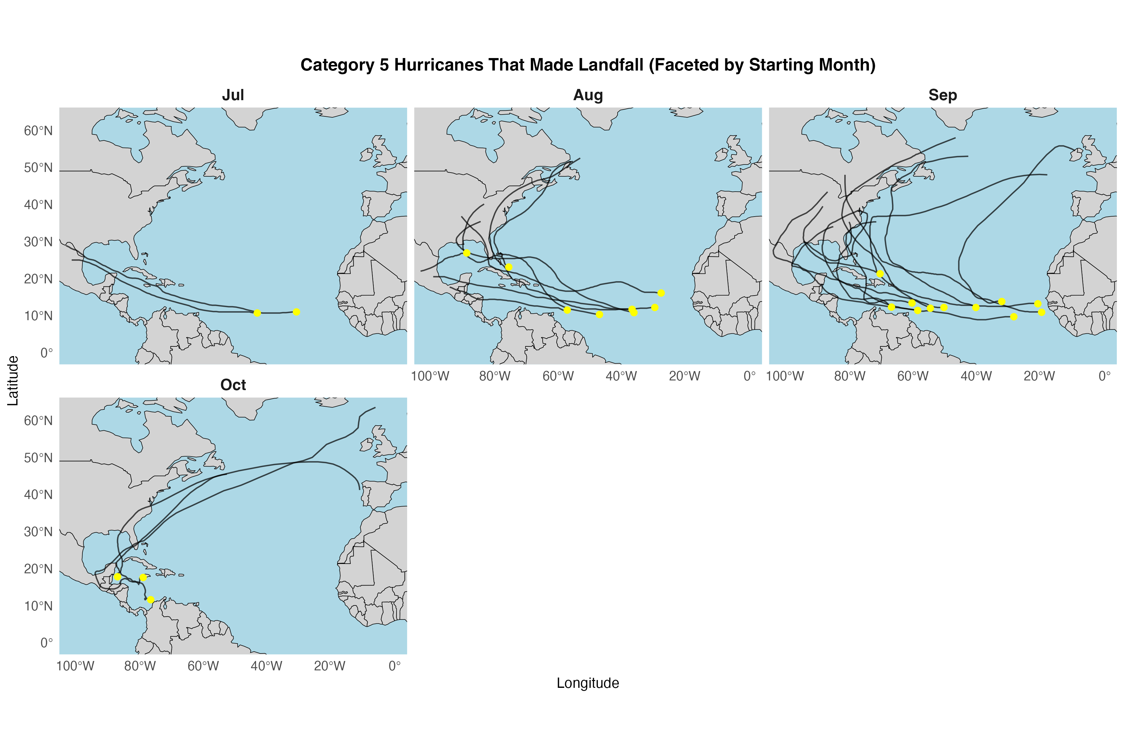
- July: Cyclone activity typically increases in the Gulf of Mexico and the western Caribbean, marking an early uptick in seasonal development.
- August: Storm generation expands into the central and eastern Atlantic, as warming sea-surface temperatures create more favorable conditions.
- September: This peak month sees widespread genesis across the tropical Atlantic, producing the highest overall storm counts.
- October: Activity begins to decline, with cyclones forming predominantly in the western Caribbean and the Gulf of Mexico before tapering off.
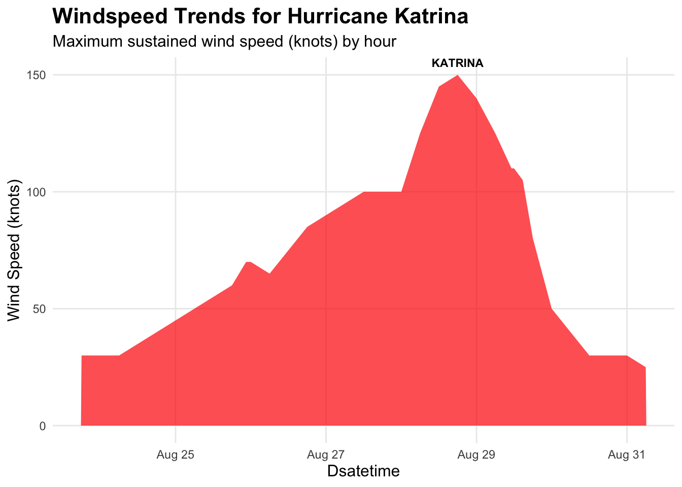
- Wind speeds exhibit a sharp increase from moderate levels around August 25–26 to an intense peak (over 150 knots) by August 29.
- Following this peak, a notable decline in sustained winds occurs, reflecting the storm’s weakening phase as it nears and crosses land.
- The rapid intensification followed by subsequent weakening exemplifies the dynamic evolution of major hurricanes influenced by ocean heat content and atmospheric conditions.